The Extended Essay
Overview
An EE in geography gives student's an opportunity to apply a range of geographic skills to complete an independent and in-depth research investigation using geographic concepts, methodologies, theories and sources with a clear spatial emphasis.
Choice of topic
The essay topic may relate to an area of the Diploma Programme geography course, but this is not a requirement. Students can also explore other areas of the wider subject, such as how global issues can be examined through the lens of geography.
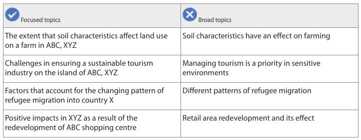
Examples of research topicsT
hese examples are for guidance only. Students must ensure their choice of topic is focused (left-hand column) rather than broad (right-hand column).
An EE in geography gives student's an opportunity to apply a range of geographic skills to complete an independent and in-depth research investigation using geographic concepts, methodologies, theories and sources with a clear spatial emphasis.
Choice of topic
The essay topic may relate to an area of the Diploma Programme geography course, but this is not a requirement. Students can also explore other areas of the wider subject, such as how global issues can be examined through the lens of geography.
Examples of research topicsT
hese examples are for guidance only. Students must ensure their choice of topic is focused (left-hand column) rather than broad (right-hand column).
Treatment of the topic
It is the task of the supervisor to ensure that the research question:
Research methods
Methodology
Students are not required to undertake primary research, but it is rare for an essay that is based entirely on the reading of published texts to score highly.
Many successful research topics are based on published data such as census or weather records.
Investigations carried out at a local scale also usually achieve highly:
Information on the methodology of the investigation is essential. If students collect their own data, it must be of high quality. It is vital that the investigation is tailored closely to the research question and shows evidence of careful planning.
Students will be assessed for their skills of analysis rather than techniques of data collection and processing. For the EE, the emphasis should be on:
Resources
Appropriate resources for an EE in geography could include:
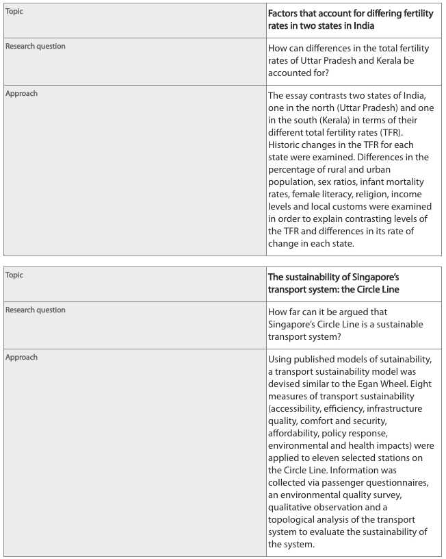
Examples of topics, research questions and suggested approachesOnce students have identified their topic and written their research question, they can decide how to research their answer. They may find it helpful to write a statement outlining their broad approach. These examples are for guidance only.
It is the task of the supervisor to ensure that the research question:
- is relevant to the subject
- allows the student to make use of appropriate geographic sources
- encourages the application of relevant subject concepts, theories or ideas.
- one or more annotated maps
- where relevant, photographs and/or satellite images.
Research methods
Methodology
Students are not required to undertake primary research, but it is rare for an essay that is based entirely on the reading of published texts to score highly.
Many successful research topics are based on published data such as census or weather records.
Investigations carried out at a local scale also usually achieve highly:
- they demonstrate connections between the subject and local manifestations and instances
- their narrow focus discourages an over-reliance on published materials and encourages original research
- students become more involved when investigating in a familiar, accessible location.
Information on the methodology of the investigation is essential. If students collect their own data, it must be of high quality. It is vital that the investigation is tailored closely to the research question and shows evidence of careful planning.
Students will be assessed for their skills of analysis rather than techniques of data collection and processing. For the EE, the emphasis should be on:
- written analysis
- interpretation
- discussion
- critical evaluation
- the development of a coherent, reasoned argument.
Resources
Appropriate resources for an EE in geography could include:
- primary and secondary data
- quantitative and qualitative information
- books, newspapers and magazines
- interviews and/or questionnaires
- the internet
- maps
- aerial photographs and satellite images
- digital landscape simulations
- videos
- GIS
- diagrams and models.
Examples of topics, research questions and suggested approachesOnce students have identified their topic and written their research question, they can decide how to research their answer. They may find it helpful to write a statement outlining their broad approach. These examples are for guidance only.
Illustrations and maps
It is essential that a geography EE be supported by appropriate illustrative graphical material, such as diagrams, maps, tables, images and graphs. Students must acknowledge the sources for each.
Maps
Images or photographs
An important note on “double-dipping”Students must ensure that their EE does not duplicate any other work they are submitting for the Diploma Programme.
The geography EE and IA
In particular, an EE in geography is not an extension of the internal assessment (IA) task. Students must ensure that they understand the differences between the two.
Supervisors play an important role in guiding students on these distinctions. Students risk their diploma if academic misconduct is detected.
It is essential that a geography EE be supported by appropriate illustrative graphical material, such as diagrams, maps, tables, images and graphs. Students must acknowledge the sources for each.
Maps
- Good essays usually have maps in the introduction to place the investigation in a clear spatial context.
- All maps should give an indication of orientation and scale, and include a legend or key.
- Students should clearly reference all maps used and give the source of any base maps they have not constructed themselves.
- The use of scanned maps or satellite images, or those that are downloaded in unaltered form, is rarely effective and provides little evidence of students’ map skills. However, students are encouraged to modify or adapt such images.
- Students are encouraged to include:
- sketch maps
- labelled or annotated diagrams
- maps they have constructed.
- If students draw maps using computer software, they should state the proprietary program used. Hand-drawn maps should be neat and clear, and employ standard map conventions.
Images or photographs
- Images or photographs should only be used if they are essential illustrative components of the essay, ie not just decoration.
- Students should explain the feature(s) an image or photograph is intended to illustrate. Each should be:
- oriented
- sourced
- labelled, annotated or captioned.
- Colour is frequently used in geographic illustrative materials, so it is important that an original colour version of the essay is submitted.
An important note on “double-dipping”Students must ensure that their EE does not duplicate any other work they are submitting for the Diploma Programme.
The geography EE and IA
In particular, an EE in geography is not an extension of the internal assessment (IA) task. Students must ensure that they understand the differences between the two.
Supervisors play an important role in guiding students on these distinctions. Students risk their diploma if academic misconduct is detected.
Interpreting the EE assessment criteria
Criterion A: Focus and method(Strands: Topic, Research question, Methodology)
The topic of the geography extended essay must be clearly indicated at the beginning. This should include the area of the research, the purpose, and the focus of the essay in order to clearly establish the context of the research question. It is usually appropriate to include the general locational background as well as appropriate geographic theory or concept required to understand how the research question has been established. Above all there should be a clear spatial component. For example, a topic statement of an essay may be ‘The distribution of textile retail shops in South Mumbai”. The explanation of this topic might revolve around location on major thoroughfares and access to a market.
The research question is best stated in the form of an actual question. An example of research question could be “To what extent does location have an impact of educational attainment of indigenous people in Queensland? The research question should be identified clearly and set out prominently at the start of the essay and on the title page.
The student needs to demonstrate within the essay that their research methodology has been well planned. It is expected that students show that they have researched the topic and selected an appropriate geographic approach to address the research question. This applies both to literature research and to practical data collection. Primary or secondary data collection is acceptable. The very best essays are likely to have a mixture of both. Students must ensure and demonstrate that their chosen methods and materials are appropriate for addressing the research question. Investigative methods should be clearly explained. The investigation should be sufficiently clear for, so that others could repeat the work. The reliability of the research should be discussed.
If students are investigating a well-documented or standard topic, they should attempt to look for a new approach or perspective to the issue. This is most likely undertaken by choosing a particular location within the student’s own experience, for example their home location. For example, a topic covering climate change may look at changes in snow cover in a ski resort. This would also help in reducing the scope to a manageable local scale.
Criterion B: Knowledge and understanding(Strands: Context, Subject-specific terminology and concepts)
The source materials accessed should be clearly relevant and appropriate to the research question. They should be effectively referenced and incorporated into the main body of the essay in a way that demonstrates the student’s understanding. Literature cited should predominantly come from acknowledged sources.
Students writing in geography need to show a mastery of, and fluency in, the use of appropriate terminology. Any technical terms or concepts that are used should be clearly explained and the student must demonstrate an understanding by using them appropriately within the text. The student must try to maintain a consistent linguistic style throughout the essay.
Criterion C: Critical thinking(Strands: Research, Analysis and Discussion and evaluation)
“Research” refers to both literature sources and data collected by the students themselves.
It must be consistently relevant to the research question.
If the research involves sampling then the selection and size of the sample must allow for valid analysis.
Students must demonstrate the ability to apply their selected sources and methods effectively in support of their argument.
Students should present and analyse the data and sources appropriately. The data must be analysed and presented in such a way that the argument leading to the conclusion is supported and clarified.
This analysis may include:
- maps of various scales and types
- statistical analysis
- tables of processed data
- graphs.
If students use maps, graphs or infographics, they must be correctly selected and drawn to illustrate key elements of the analysis. They should only be included if they aid communication.
Students should aim to maintain a reasoned, logical argument that focuses on the research question. Essays that attempt to deal with a large number of variables are unlikely to be focused and coherent.
Students can achieve a clear and logical argument by making repeated reference to the research question and to any hypotheses derived from it. Students’ assessment of the extent to which a hypothesis is supported or the question is answered by the data should form part of the argument.
The stated conclusion(s) must be based on and consistent with the research presented in the essay.
Geographic research often reveals unexpected outcomes and students should point these out. The original research question may not be fully answered by the investigation. In these cases, the student should point out unresolved issues and make suggestions as to how these might be further investigated.
Students must comment on the reliability, quantity, balance and quality of their research, including their own data collection and published material. They should show an awareness of any limitations or uncertainties inherent in their approach. In particular, they should critically comment on the validity and reliability of their data relative to their management of variables within the investigation.
Criterion D: Presentation(Strands: Structure, Layout)
This criterion relates to the extent to which the essay conforms to accepted academic standards in relation to how research papers should be presented. It also relates to how well these elements support the reading, understanding and evaluation of the essay.
Students must provide a section and subsection structure to their essays, with appropriate informative headings. Graphics should be set out and analysed at relevant points within the essay and not set out at the end.
Geography is a graphical subject and maps, graphs, infographics, images and tables from literature sources can be included in the essay. They must be carefully selected, labelled and referenced. They should only be used if they are directly relevant to the research question, contribute towards the understanding of the argument and are of a good graphic quality.
Students’ own graphical material should also be carefully selected. If scanned in, they should be of good quality and legible.
Large tables of raw data collected by the student are best included in an appendix, where they should be carefully labelled. Tables of processed data should be designed to clearly display the information in the most appropriate form. Graphical representation of data, especially spatial, is to be encouraged.
The importance of good mapping techniques cannot be overemphasized. Maps, graphs or infographics drawn from the analysed data should be selected to highlight only the most pertinent aspects related to the argument. Too many graphs, charts and tables may distract from the overall impression. If tables contain a lot of text, these words will be included in the word count.
Any material that is not original must be carefully acknowledged, with specific attention paid to the acknowledgment and referencing of quotes and ideas. This acknowledgment and referencing is applicable to audiovisual material, text, graphs and data published in print and electronic sources. If the referencing does not meet the minimum standard as indicated in the guide (name of author, date of publication, title of source and page numbers as applicable), and is not consistently applied, work will be considered as a case of possible academic misconduct.
A bibliography is essential and has to be presented in a standard format. Title page, table of contents, page numbers, etc must contribute to the quality of presentation.
The essay must not exceed 4,000 words of narrative. Maps, graphs, figures, infographics, calculations, diagrams, formulas and equations are not included in the word count. Students should be aware that examiners will not read beyond the 4,000-word limit, or assess any material presented thereafter.
Criterion E: Engagement(Strands: Process, Research focus)
This criterion assesses the student’s engagement with their research focus and the research process. It will be applied by the examiner at the end of the assessment of the essay, and is based solely on the candidate’s reflections as detailed on the RPPF, with the supervisory comments and extended essay itself as context.
Students are expected to provide reflections on the decision-making and planning process undertaken in completing the essay. Students must demonstrate how they arrived at a topic as well as the methods and approach used. This criterion assesses the extent to which a student has evidenced the rationale for decisions made throughout the planning process and the skills and understandings developed.
For example, students may reflect on:
- the approach and strategies they chose, and their relative success
- the Approaches to learning skills they have developed and their effect on the student as a learner
- how their conceptual understandings have developed or changed as a result of their research
- challenges they faced in their research and how they overcame these
- questions that emerged as a result of their research
- what they would do differently if they were to undertake the research again.
The reflections must provide the examiner with an insight into student thinking, creativity and originality within the research process. The student voice must be clearly present and demonstrate the learning that has taken place.
Reflection Resources
- Tips: Tips for writing better EE reflections
- Tips: Tips for writing better EE reflections